Map
View
| To have suggestions and examples displayed in the App Editor during configuration, press Ctrl+Space. |
Initial view
Required bundle: map-init
To set the view that is displayed when an app starts, you can use the Live configuration. Open the section Map → Initial View. Then change the map or 3D scene to the view that should be displayed when the app is launched. You can close the configuration window in between. To reopen it to save the setting, click Live configuration again.
Alternatively, the values can be set in the App Editor:
{
    "map-init": {
        "Config": {
            "map": {},
            "view": {
                "viewmode": "2D",
                "scale": 328083,
                "center": {
                    "x": 803388,
                    "y": 6604631,
                    "spatialReference": {
                        "wkid": 3857
                    }
                }
            }
        }
    }
}{
"map-init": {
"Config": {
"map": {},
"view": {
"viewmode": "3D",
"camera": {
"heading": 338.0030989113829,
"tilt": 77.24010183113229,
"position": {
"x": 795277.8187824533,
"y": 6569001.517765303,
"z": 6368.919585980475,
"spatialReference": {
"wkid": 102100
}
}
}
}
}
}
}|
Switch view between 2D and 3D
The bundle viewmodeswitcher provides a tool to change the view within an app between 2D and 3D.
To restrict the visibility of specific map contents to the 2D or 3D view, see 2D and 3D visibility.
|
| For more information about configuration, see the bundle documentation . |
Restrict navigation
To restrict navigation in a view (for example only allow navigation at a certain scale or map extent or prevent rotation of the map), use the settings described in the constraints section of the bundle documentation .
Content
Required bundle: map-init
| To have suggestions and examples displayed in the App Editor during configuration, press Ctrl+Space. |
Supported service and layer types
The setting of further options and the addition of further types of maps can be done in the App Editor. The following table gives an overview of supported service and layer types.
| Name | Type | Configuration | Sample |
|---|---|---|---|
ArcGIS Building Scene Layer |
|
||
ArcGIS Elevation Layer |
|
||
ArcGIS Feature Layer |
|
||
ArcGIS Image Service |
|
||
ArcGIS Integrated Mesh Layer |
|
||
ArcGIS Map Service (cached) |
|
||
ArcGIS Map Service (dynamic) |
|
||
ArcGIS Point Cloud Layer |
|
||
ArcGIS Scene Service |
|
||
ArcGIS Stream Layer |
|
||
ArcGIS Tiled Image Service |
|
||
ArcGIS Vector Tile Layer |
|
||
ArcGIS Voxel Layer |
|
||
Bing Maps |
|
||
CSV File |
|
||
GeoJSON |
|
||
GeoRSS |
|
||
Group Layer |
|
||
KML File |
|
||
OGC API Features |
|
||
OGC Web Feature Service (WFS 2.0.0 with GeoJSON output format) |
|
||
OGC Web Map Service |
|
||
OGC Web Map Tile Service |
|
||
Open Street Map |
|
||
Web Tile Layer |
|
Basemaps
Basemaps are usually maps that cover a large area and are displayed behind thematic layers. Various service types can be used to integrate basemaps. These are usually
Use the parameter "selected": true to define the basemap that is activated at the start of an app.
Esri basemaps
|
Use of these basemaps requires either an ArcGIS Location Platform account, ArcGIS Online organizational subscription, or an ArcGIS Enterprise license. Further information is listed or linked in the Esri documentation . To set an API key for the use of ArcGIS resources, read ArcGIS API-Key. |
Basemap Styles Service
Esri basemaps can be used via defined IDs. The integration is done by using the Basemap styles service . To do this, enter one of the IDs listed under ArcGIS styles (“API reference” column).
{
    "map-init": {
        "Config": {
            "basemaps": [
                {
                    "id": "esri-basemap-1",
                    "basemap": {
                        "style": {
                            "id": "arcgis/streets"
                        }
                    }
                }
            ],
            "map": {}
        }
    }
}
Basemap IDs
| For 2D maps, this mode is marked as “legacy” by Esri. |
Alternatively, a basemap can be defined via an ID. To do this, enter one of the Esri basemap IDs .
{
    "map-init": {
        "Config": {
            "basemaps": [
                {
                    "id": "esri-basemap-2",
                    "title": "Streets",
                    "selected": true,
                    "basemap": "streets-vector"
                }
            ],
            "map": {}
        }
    }
}
ArcGIS Vector Tile Layer
{
    "map-init": {
        "Config": {
            "basemaps": [
                {
                    "id": "darkgray",
                    "title": "Dark Gray Canvas",
                    "selected": true,
                    "basemap": {
                        "type": "AGS_VECTORTILE",
                        "url": "https://www.arcgis.com/sharing/rest/content/items/c11ce4f7801740b2905eb03ddc963ac8/resources/styles/root.json"
                    }
                }
            ],
            "map": {}
        }
    }
}
ArcGIS Tiled Map Service
{
    "map-init": {
        "Config": {
            "basemaps": [
                {
                    "id": "custom_gray",
                    "title": "Gray",
                    "description": "This basemap uses a custom layer",
                    "selected": true,
                    "basemap": {
                        "type": "AGS_TILED",
                        "url": "https://services.arcgisonline.com/arcgis/rest/services/Canvas/World_Light_Gray_Base/MapServer"
                    }
                }
            ],
            "map": {}
        }
    }
}
WMS
Minimal configuration:
{
    "map-init": {
        "Config": {
            "basemaps": [
                {
                    "id": "topplus2",
                    "title": "WMS (TopPlus-Web-Open)",
                    "selected": true,
                    "basemap": {
                        "type": "WMS",
                        "url": "https://sgx.geodatenzentrum.de/wms_topplus_web_open"
                    }
                }
            ],
            "map": {}
        }
    }
}
Sample with further parameters:
{
    "map-init": {
        "Config": {
            "basemaps": [],
            "map": {
                "layers": [
                    {
                        "id": "topplus2",
                        "title": "WMS (TopPlus-Web-Open)",
                        "type": "WMS",
                        "url": "https://sgx.geodatenzentrum.de/wms_topplus_web_open",
                        "sublayers": [
                            {
                                "name": "web",
                                "title": "TopPlusOpen"
                            }
                        ],
                        "imageFormat": "image/png32",
                        "version": "1.3.0",
                        "customParameters": {
                            "styles": "my-style",
                            "bgcolor": "FF0000",
                            "another": "parameter"
                        }
                    }
                ]
            }
        }
    }
}
WMTS
Minimal configuration:
{
    "map-init": {
        "Config": {
            "basemaps": [
                {
                    "id": "topplus1",
                    "title": "WMTS (TopPlus-Web-Open)",
                    "selected": true,
                    "basemap": {
                        "type": "WMTS",
                        "url": "https://sgx.geodatenzentrum.de/wmts_topplus_web_open"
                    }
                }
            ],
            "map": {}
        }
    }
}
Sample with further parameters:
{
    "map-init": {
        "Config": {
            "basemaps": [
                {
                    "id": "topplus1",
                    "title": "WMTS (TopPlus-Web-Open)",
                    "selected": true,
                    "basemap": {
                        "type": "WMTS",
                        "url": "https://sgx.geodatenzentrum.de/wmts_topplus_web_open",
                        "activeLayer": {
                            "id": "web"
                        },
                        "customLayerParameters": "",
                        "customParameters": "",
                        "copyright": "Copyright text",
                        "minScale": 2000000,
                        "maxScale": 100000,
                        "serviceMode": "RESTful"
                    }
                }
            ],
            "map": {}
        }
    }
}
If a WMTS service is not loading correctly, try setting the serviceMode parameter to the value KVP.
|
For more information about the parameters, see the documentation for the WMTS Layer in the ArcGIS Maps SDK for JavaScript.
Multiple basemaps
To provide the capability to switch between different basemaps (see map control), several basemaps can be configured in one app.
{
    "map-init": {
        "Config": {
            "basemaps": [
                {
                    "id": "streets",
                    "title": "Streets",
                    "selected": true,
                    "basemap": "streets-vector"
                },
                {
                    "id": "topo",
                    "title": "Topographic",
                    "basemap": "topo-vector"
                }
            ],
            "map": {}
        }
    }
}
Combine multiple maps into one basemap
With the help of the following configuration two maps can be combined to a basemap. For the user only one entry appears in the app.
{
    "map-init": {
        "Config": {
            "basemaps": [
                {
                    "id": "combined",
                    "title": "Grundkarte",
                    "basemap": [
                        {
                            "type": "AGS_VECTORTILE",
                            "url": "https://www.arcgis.com/sharing/rest/content/items/c11ce4f7801740b2905eb03ddc963ac8/resources/styles/root.json",
                            "opacity": 0.5
                        },
                        {
                            "type": "AGS_TILED",
                            "url": "https://services.arcgisonline.com/arcgis/rest/services/Elevation/World_Hillshade/MapServer"
                        }
                    ],
                    "selected": true
                }
            ],
            "map": {}
        }
    }
}
With the following configuration, the map is changed at a scale of 1:1,000,000.
{
    "map-init": {
        "Config": {
            "basemaps": [
                {
                    "id": "combined",
                    "title": "Grundkarte",
                    "basemap": [
                        {
                            "type": "AGS_TILED",
                            "url": "https://services.arcgisonline.com/ArcGIS/rest/services/Canvas/World_Light_Gray_Base/MapServer",
                            "minScale": 1000000
                        },
                        {
                            "type": "AGS_TILED",
                            "url": "https://services.arcgisonline.com/arcgis/rest/services/Ocean/World_Ocean_Base/MapServer",
                            "maxScale": 1000000
                        }
                    ],
                    "selected": true
                }
            ],
            "map": {}
        }
    }
}
Ground (elevation layer)
In order to store information about the surface profile (for example to display it in a 3D view or to use it for an elevation profile query in a 2D map), a so-called elevation layer must be configured.
The following configuration uses a worldwide elevation profile provided by Esri:
{
    "map-init": {
        "Config": {
            "basemaps": [],
            "map": {
                "layers": [],
                "ground": "world-elevation"
            }
        }
    }
}
With the following configuration, any elevation layer can be used:
{
    "map-init": {
        "Config": {
            "basemaps": [],
            "map": {
                "layers": [],
                "ground": [
                    {
                        "url": "https://elevation3d.arcgis.com/arcgis/rest/services/WorldElevation3D/Terrain3D/ImageServer",
                        "type": "AGS_ELEVATION"
                    }
                ]
            }
        }
    }
}
Layers
Thematic maps are displayed on top of basemaps.
Their configuration is similar to that of the basemaps, but the parameter "selected": true does not exist for thematic maps.
Instead, the parameter "visible": true or "visible": false can be used to determine whether the map or layer is visible when the app is started.
ArcGIS Feature Layer
{
    "map-init": {
        "Config": {
            "basemaps": [],
            "map": {
                "layers": [
                    {
                        "id": "layer1",
                        "type": "AGS_FEATURE",
                        "url": "https://www.example.com/arcgis/rest/services/myservice/FeatureServer/0",
                        "visible": true
                    }
                ]
            }
        }
    }
}
ArcGIS map service
To display the map service with all layers and retrieve the layer structure and other metadata, such as layer titles, dynamically from the server, use the following configuration:
{
    "map-init": {
        "Config": {
            "basemaps": [],
            "map": {
                "layers": [
                    {
                        "id": "test",
                        "type": "AGS_DYNAMIC",
                        "url": "https://www.example.com/arcgis/rest/services/myservice/MapServer"
                    }
                ]
            }
        }
    }
}
To display only certain layers or to customize the configuration of individual layers (for example, the title), use the following configuration:
{
    "map-init": {
        "Config": {
            "basemaps": [],
            "map": {
                "layers": [
                    {
                        "id": "test",
                        "title": "My custom Title",
                        "type": "AGS_DYNAMIC",
                        "url": "https://www.example.com/arcgis/rest/services/myservice/MapServer",
                        "sublayers": [
                            {
                                "id": 2,
                                "title": "My custom Title"
                            },
                            {
                                "id": 3
                            }
                        ]
                    }
                ]
            }
        }
    }
}|
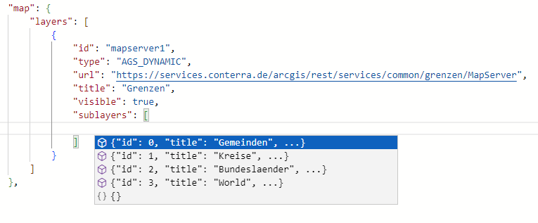
Support in app editor To get a list of layers available in the map service, press Ctrl+Space while the cursor is in the array
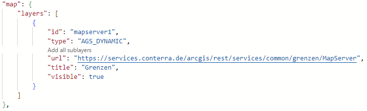
To add all layers in their hierarchical structure to the configuration, click Add all sublayers above the URL of the service.
|
OGC API Features
{
    "map-init": {
        "Config": {
            "basemaps": [],
            "map": {
                "layers": [
                    {
                        "id": "fluren",
                        "title": "Flurstücke in NRW",
                        "type": "OGC_FEATURE",
                        "url": "https://ogc-api.nrw.de/lika/v1/",
                        "collectionId": "flurstueck",
                        "objectIdField": "objid",
                        "copyright": "Geobasis NRW",
                        "limit": 5000
                    }
                ]
            }
        }
    }
}
The limit-parameter sets the default value to limit the number of features returned for a single query.
WFS
The service has to provide GeoJSON as an output format.
{
    "map-init": {
        "Config": {
            "basemaps": [],
            "map": {
                "layers": [
                    {
                        "id": "kitas_wfs_layer",
                        "title": "Kindertagesstätten",
                        "type": "WFS",
                        "url": "https://www.stadt-muenster.de/ows/mapserv706/kitaserv",
                        "name": "ms:kitas01",
                        "visible": true
                    }
                ]
            }
        }
    }
}
OGC WMS
{
    "map-init": {
        "Config": {
            "basemaps": [],
            "map": {
                "layers": [
                    {
                        "id": "topplus2",
                        "title": "WMS (TopPlus-Web-Open)",
                        "type": "WMS",
                        "url": "https://sgx.geodatenzentrum.de/wms_topplus_web_open",
                        "sublayers": [
                            {
                                "name": "web",
                                "title": "TopPlusOpen"
                            }
                        ]
                    }
                ]
            }
        }
    }
}
Integrate map as ArcGIS Portal item
Instead of specifying a URL, you can configure a map via the ID of the element in ArcGIS Portal. Use the following configuration for this:
{
    "map-init": {
        "Config": {
            "basemaps": [],
            "map": {
                "layers": [
                    {
                        "title": "Layer From Portalitem",
                        "portalItem": {
                          "id": "1e6a26701cd94ca1880e6fc9c908f410",
                          "portal": "https://www.arcgis.com"
                        },
                        "type": "AGS_FEATURE"
                      }
                ]
            }
        }
    }
}
Exclusive mode for a group of maps
To offer several maps, of which only one should be displayed at a time (for example, different years on a topic), combine the individual maps in a group layer and use the configuration "visibilityMode": "exclusive" as in the following example:
{
    "map-init": {
        "Config": {
            "basemaps": [],
            "map": {
                "layers": [
                    {
                        "id": "group",
                        "title": "Unfälle 2018",
                        "type": "GROUP",
                        "visibilityMode": "exclusive",
                        "layers": [
                            {
                                "id": "unfaelle1",
                                "title": "Alle",
                                "type": "AGS_FEATURE",
                                "url": "https://services2.arcgis.com/jUpNdisbWqRpMo35/arcgis/rest/services/Verkehrsunf%C3%A4lle__2018/FeatureServer/0"
                            },
                            {
                                "id": "unfaelle2",
                                "title": "Tag",
                                "type": "AGS_FEATURE",
                                "url": "https://services2.arcgis.com/jUpNdisbWqRpMo35/arcgis/rest/services/Verkehrsunf%C3%A4lle__2018/FeatureServer/0",
                                "definitionExpression": "ULICHTVERH = '0'"
                            },
                            {
                                "id": "unfaelle3",
                                "title": "Abend",
                                "type": "AGS_FEATURE",
                                "url": "https://services2.arcgis.com/jUpNdisbWqRpMo35/arcgis/rest/services/Verkehrsunf%C3%A4lle__2018/FeatureServer/0",
                                "definitionExpression": "ULICHTVERH = '1'"
                            },
                            {
                                "id": "unfaelle4",
                                "title": "Nacht",
                                "type": "AGS_FEATURE",
                                "url": "https://services2.arcgis.com/jUpNdisbWqRpMo35/arcgis/rest/services/Verkehrsunf%C3%A4lle__2018/FeatureServer/0",
                                "definitionExpression": "ULICHTVERH = '2'"
                            }
                        ]
                    }
                ]
            }
        }
    }
}| For more information about configuration, see the bundle documentation . |
2D and 3D visibility
You can specify for each base and thematic map whether it is only displayed in 2D or 3D view or in both views.
Visibility of basemaps
To define the visibility of basemaps depending on the view mode (2D or 3D), set the parameter “viewmode”: “2D” or “viewmode”: “3D” in the configuration of the basemap.
In the following example, a basemap combined from two layers is configured. Depending on the view mode, one of the two layers is displayed.
The advantage of combining the two layers into one basemap is, that the basemap remains always active, even if the view is switched between 2D and 3D.
{
    "map-init": {
        "Config": {
            "basemaps": [
                {
                    "id": "streets",
                    "selected": true,
                    "basemap": [
                        {
                            "id": "streets-2d",
                            "type": "AGS_VECTORTILE",
                            "url": "https://basemaps.arcgis.com/arcgis/rest/services/World_Basemap_v2/VectorTileServer",
                            "viewmode": "2D"
                        },
                        {
                            "type": "GROUP",
                            "layers": [
                                {
                                    "id": "streets-3d",
                                    "type": "AGS_VECTORTILE",
                                    "url": "https://basemaps.arcgis.com/arcgis/rest/services/OpenStreetMap_v2/VectorTileServer"
                                },
                                {
                                    "id": "buildings-3d",
                                    "type": "AGS_SCENE",
                                    "url": "https://basemaps3d.arcgis.com/arcgis/rest/services/OpenStreetMap3D_Buildings_v1/SceneServer"
                                }
                            ],
                            "viewmode": "3D"
                        }
                    ]
                }
            ]
        }
    }
}
Visibility of thematic layers
To display a layer only in a specific view mode (2D or 3D), set the parameter “viewmode”: “2D” or “viewmode”: “3D” in the configuration of the layer.
In the following example, two layers are configured for the display of standard land values in the city of Münster from the same FeatureServer. The layer configured for the 3D view defines a special renderer for the three-dimensional display of these values. This layer is only displayed in the 3D view. When the view is switched to 2D, this layer is hidden and the 2D equivalent is displayed.
{
    "map-init": {
        "Config": {
            "map": {
                "layers": [
                    {
                        "id": "ground-values-2d",
                        "url": "https://services.arcgis.com/ObdAEOfl1Z5LP2D0/arcgis/rest/services/BRW2016_Muenster/FeatureServer/0",
                        "type": "AGS_FEATURE",
                        "viewmode": "2D"
                    },
                    {
                        "id": "ground-values-3d",
                        "url": "https://services.arcgis.com/ObdAEOfl1Z5LP2D0/arcgis/rest/services/BRW2016_Muenster/FeatureServer/0",
                        "type": "AGS_FEATURE",
                        "viewmode": "3D",
                        "renderer": {
                            "type": "simple",
                            "symbol": {
                                "type": "polygon-3d",
                                "symbolLayers": [
                                    {
                                        "type": "extrude"
                                    }
                                ]
                            },
                            "visualVariables": [
                                {
                                    "type": "size",
                                    "field": "BRW_INT",
                                    "stops": [
                                        {
                                            "value": 0,
                                            "size": 10
                                        },
                                        {
                                            "value": 10000,
                                            "size": 10000
                                        }
                                    ]
                                },
                                {
                                    "type": "color",
                                    "field": "BRW_INT",
                                    "stops": [
                                        {
                                            "value": 0,
                                            "color": "#FEF1E4"
                                        },
                                        {
                                            "value": 1561,
                                            "color": "#BA5E34"
                                        }
                                    ]
                                }
                            ]
                        }
                    }
                ]
            }
        }
    }
}
To replace one layer with another when switching from 2D to 3D, add both layers to a group layer whose sub-elements you hide, as shown in the following configuration:
{
    "map-init": {
        "Config": {
            "basemaps": [],
            "map": {
                "layers": [
                    {
                        "id": "grouplayer1",
                        "title": "Buildings",
                        "type": "GROUP",
                        "listMode": "hide-children",
                        "layers": [
                            {
                                "id": "buildings-2d",
                                "type": "AGS_FEATURE",
                                "url": "https://www.example.com/arcgis/rest/services/buildingfootprints/FeatureServer",
                                "viewmode": "2D"
                            },
                            {
                                "id": "buildings-3d",
                                "type": "AGS_SCENE",
                                "url": "https://www.example.com/arcgis/rest/services/buildings/SceneServer",
                                "viewmode": "3D"
                            }
                        ]
                    }
                ]
            }
        }
    }
}
With this configuration, the visibility status of the layer is retained when the view is changed.
ArcGIS web maps and web scenes
Required bundle: portal-webitem-map
map.apps can load web maps or web scenes from ArcGIS Enterprise portal or ArcGIS Online. The full configuration is taken directly from web map or scene and an additional map configuration is not required inside the app.
To add an element, the section ArcGIS Online and ArcGIS Enterprise portal → ArcGIS Web Maps and Web Scenes can be used in the live configuration. A simplified search for elements is available in this dialog.
Alternatively, the values can be set in the App Editor.
{
    "portal-webitem-map": {
        "Config": {
            "portalItem": {
                "id": "31874da8a16d45bfbc1273422f772270",
                "portal": "https://www.example.com/arcgis"
            }
        }
    }
}
If the portal parameter is omitted, the element is loaded from the ArcGIS Enterprise portal defined in the global configuration.
If the configuration is done by using a web map or web scene as described before, no configuration should be done in the app in the bundle map-init.
|
| For more information about configuration, see the bundle documentation . |
ArcGIS API key
For the use of certain ArcGIS resources, an API key is required. To create an API key, read the Tutorial: Create an API key.
To set an API key that is used in all apps, configure the global configuration:
# application.properties
esri.api.apiKey=YOUR_API_KEY
To configure an API key for an individual app, set the following configuration in the app:
// app.json
{
    // ...
    "properties": {
        "esriApiKey": "YOUR_API_KEY"
    }
}
If an API key has been set both in the app and globally, the key configured in the app is used.