Indexing of ArcGIS Server layers
smart.finder allows you to index layers of an ArcGIS Feature Server and ArcGIS Map Server. To do this, you must adapt the indexing schema and create a mapping of the attributes of a feature type in the schema. The following example shows you the necessary steps.
smart.finder Server is delivered with a preconfigured ArcGIS Feature Server Setup. This setup consists of:
-
A Solr Core with preconfigured schema (
smartsearch) -
A sample app called
full-screen-map-multicore
Both the indexing scheme and the layer configuration are already prepared for indexing a layer Points of Interest in Münster with a total of 18739 features. You can use this example as a blueprint for setting up additional layers. The following section explains in detail what has to be done for this.
Data basis
Let’s assume that you want to index a layer for Points of Interest in Münster. A feature of this layer has the following fields:
-
FID (type: esriFieldTypeOID, alias: FID, SQL Type: sqlTypeOther, length: 0, nullable: false, editable: false)
-
osm_id (type: esriFieldTypeString, alias: osm_id, SQL Type: sqlTypeOther, length: 10, nullable: true, editable: true)
-
code (type: esriFieldTypeSmallInteger, alias: code, SQL Type: sqlTypeOther, nullable: true, editable: true)
-
fclass (type: esriFieldTypeString, alias: fclass, SQL Type: sqlTypeOther, length: 28, nullable: true, editable: true)
-
name (type: esriFieldTypeString, alias: name, SQL Type: sqlTypeOther, length: 100, nullable: true, editable: true)
-
Shape__Area (type: esriFieldTypeDouble, alias: Shape__Area, SQL Type: sqlTypeDouble, nullable: true, editable: false)
-
Shape__Length (type: esriFieldTypeDouble, alias: Shape__Length, SQL Type: sqlTypeDouble, nullable: true, editable: false)
The fields osm_id, code and name should be taken into account when indexing the features.
Adaptation of the schema
smart.finder is delivered with a preconfigured core for this use case.
The smartsearch core is located in the directory solr.home:
/smartfinder-search/WEB-INF/solr.home/smartsearch
<fields>
    <field name="identifier" type="string" indexed="true" stored="true" required="false" multiValued="true"/>
    <field name="title" type="text" indexed="true" stored="true" required="false" multiValued="false"/>
    <field name="layer" type="text" indexed="true" stored="true" required="false" multiValued="false"/>
    [...]
    <field name="poi_name" type="text" indexed="true" stored="true" required="false" multiValued="false"/>
    <field name="poi_code" type="text" indexed="true" stored="true" required="false" multiValued="false"/>

    <!-- copy to search field -->
    <copyField source="identifier" dest="full_text"/>
    <copyField source="title" dest="full_text"/>
    <copyField source="layer" dest="full_text"/>
    <copyField source="poi_name" dest="full_text"/>
    <copyField source="poi_code" dest="full_text"/>
    [...]
</fields>
The following fields are mandatory in the Smart Search schema:
- layer
-
Saves the name of the indexed layer
- title
-
Explicit representation of search results is used
Further, you can add fields synonymously to the above mentioned procedure depending on the indexed ArcGIS Service Layer.
Link layer and schema
The link between the fields of the layer and the schema is established by the file /smartfinder-search/WEB-INF/classes/spring-feature-layer-config.xml.
The existing (and executable) example shows how to map the names of the fields of the layer to the fields of the schema.
To create a new layer configuration, copy the existing example, paste it into a new file, and then modify it to meet your needs.
<?xml version="1.0" encoding="UTF-8"?>
<beans xmlns="http://www.springframework.org/schema/beans"
       xmlns:xsi="http://www.w3.org/2001/XMLSchema-instance"
       xmlns:util="http://www.springframework.org/schema/util"
       xsi:schemaLocation="http://www.springframework.org/schema/beans http://www.springframework.org/schema/beans/spring-beans.xsd
                            http://www.springframework.org/schema/util http://www.springframework.org/schema/util/spring-util-3.0.xsd">
    <util:list id="layerConfigurations">
        <!-- Configuration for indexing feature layer with id 0 -->
        <bean class="de.conterra.finder.api.arcgis.arcgisserver.LayerConfiguration" name="layerConfigurationFederalStates">
            [...]
        </bean>
        <!-- Configuration of new custom layer -->
        <bean class="de.conterra.finder.api.arcgis.arcgisserver.LayerConfiguration" name="layerCustomFeatureServer">
            [...]
        </bean>
    </util:list>
</beans>
The following settings can be made for the Feature Server or Map Server Layer:
name-
erforderlich
Unique name of the layer configuration.
Example:<bean class="de.[...].LayerConfiguration" name="<NAME_DER_KONFIGURATION>"> [...] </bean> arcGISServerUrl-
erforderlich
URL to the layer of the ArcGIS Feature or Map Server. id-
erforderlich
ID of the layer. descriptiveName-
Descriptive name of the layer.
This is used to display the categories of search hits. pageSize-
Maximum number of requested features per request against the layer.
If this value is not set, the value globally configured for the indexing service
arcgisServerContentIndexingServicefrom the file/smartfinder-search/WEB-INF/classes/spring-indexing-config.xmlis used. indexedFieldsToSchemaMapping-
erforderlich
Mapping the fields of the schema to the fields of the layer.
In general:<entry key="<NAME_OF_FIELD_IN_LAYER>" value="<NAME_OF_FIELDS_IN_SCHEMA>"/>
Example:<property name="indexedFieldsToSchemaMapping"> <map> <entry key="osm_id" value="identifier"/> <entry key="code" value="poi_code"/> <entry key="name" value="poi_name"/> </map> </property>
The fields osm_id, code and name are attributes of the feature layer, the corresponding fields identifier, poi_code and poi_name are the fields of the schema into which the values are indexed.
titleFields-
erforderlich
Appearance of the title field.
This is used to display the hits in the search box.
If you want to create a title for a feature with name="Roads" and code="0428" that is "- Roads (0428)", create the following configuration:
 <property name="titleFields">
    <list>
        <bean class="de.conterra.finder.api.arcgis.arcgisserver.TitleField">
            <property name="name" value="name"/>
            <property name="postDelimiter" value=" ("/>
            <property name="preDelimiter" value="- "/>
        </bean>
        <bean class="de.conterra.finder.api.arcgis.arcgisserver.TitleField">
            <property name="name" value="code"/>
            <property name="postDelimiter" value=")"/>
        </bean>
    </list>
</property>
Use the postDelimiter and preDelimiter properties to create the final title.
indexGeometry-
Defines whether the geometry of a feature should be indexed.
Default:true translateDomainValues-
Defines whether existing domain values of features should be considered as names in the index.
Iffalse, only the code of one field is taken.
Default:false
Indexing of the layer
To index the layer, create an indexing job for a resource of type URL in the Job Manager .
The URL of these jobs points to the Feature Server layer that you previously defined in the layer configuration.
Related to this is the URL: <arcGISServerUrl>/<id>.
For the prebuilt example, the URL is: https://services.arcgis.com/ObdAEOfl1Z5LP2D0/arcgis/rest/services/poi_muenster_WFL1/FeatureServer/0
After starting the job, the fields of the layer are indexed according to the configuration.
|
If the feature layer contains the error code You can solve this in two different ways:
|
Result of the indexing
-
To see the results open the example app:
https://<yourserver>/smartfinder/?lang=en&app=full-screen-map-multicore. -
Select the smart search core:
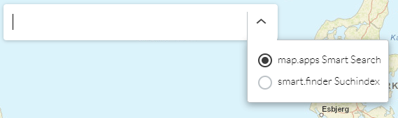
-
After entering the search term
Schule, the search result is as follows: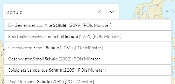
-
A click on a search result in the list shows the feature on the map.